|
Back to HikeArkansas.com Guidebook online store |
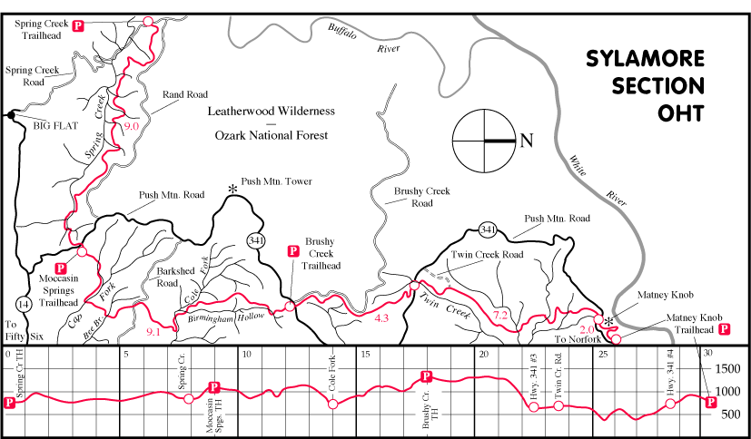
This is a brand new section of the Ozark Highlands/Trans-Ozarks Trail, and we will refer to it as the Sylamore Section. All of it is located within the Ozark National Forest, Sylamore Ranger District (headquarters in Mtn. View). Right now the section begins on Spring Creek Road, which is where the mileage and milepoints begin. The trail goes around the Leatherwood Wilderness Area but never enters it. At some point in the future the trail may be extended to the west, down to Big Creek, and through the Lower Buffalo Wilderness Area, and eventually connect with the main part of the OHT. This 40+ mile section has not been approved yet by the National Park Service at Buffalo National River.
The trail follows Spring Creek upstream into its headwaters, using a route that is mostly high up on the hillside, often running just below a wonderful bluffline. The trail doesnít actually get down to Spring Creek until far up in the headwaters. Then the trail climbs out of the drainage, making the first of four crossings of Push Mountain Road, which is also Hwy. 341. The trail continues east, dropping down into Cap Fork before turning north and crossing Barkshed Road. Soon after that point it follows Cripple Turkey Road for a while before branching off and crossing Cole Fork. Then it makes its way up into Birmingham Hollow, and up to the second crossing of Push Mtn. Road/Hwy. 341. The trail continues north, running alongside Advance/Brushy Creek Road before dropping down to and across Push Mtn. Road/Hwy. 341 for a third time near Twin Creek. From there the terrain is mostly level for a while as the trail follows Twin Creek, then runs along Twin Creek Road. The trail leaves the road after about a mile and heads back into the woods, climbing up and down a bit, following several old roads, then making a fourth crossing of Hwy. 341. The trail then makes its way around Matney Knob, and finally comes down and back out to Hwy. 341 one last time where it ends, completing this 31.6 mile of new trail.
From that point on the trail will coincide with highways all the way to the Lake Norfork Dam, where the route will become hiking trail again, making its way further north along the lake shore and eventually into Missouri, where it will connect with the Ozark Trail.
There are four trailheads. They are located on Spring Creek Road (Spring Creek Trailhead), at the first crossing of Hwy. 341 (Moccasin Spring Trailhead), and at the second crossing of Hwy. 341 (Brushy Creek Trailhead - used to be Birmingham Hollow Trailhead but they just changed the name). And the final parking area is at the end of the trail on Hwy.l 341 which is the Matney Knob Trailhead. All four trailheads are well marked on the highway.
The trail is marked with 2" x 6" white aluminum blazes nailed to trees. A blaze with a black mile number on it is located each mile along the route, beginning with the Spring Creek Trailhead as mile 0. Camping is allowed at any point along the trail, although it is best to camp out of sight of the trail and at least 200 feet from any water source. There are a number of water sources along the route, and are noted in the text that follows here. Most of the creek crossings are dry crossings much of the year - meaning that you can hop across on rocks without getting your feet wet - but during periods of high water and heavy runoff you may have to wade the creeks. It is always advisable never to cross any water that you cannot see the bottom of!
If you want to hike this trail and need car shuttle service, or a nice cabin or meal at a very reasonable price, please contact Cody's Restaurant and Cabins at 870-757-2270
DIRECTIONS TO THE TRAILHEADS
Spring Creek Trailhead. To get to the trailhead
take Hwy. 14 east out of Big Flat for about 4 miles, then TURN LEFT (north)
onto Push Mtn. Road/Hwy. 341 (paved). Go 2.3 miles and TURN LEFT
onto Rand Road/Forest Road #1118 (you will pass the Moccasin Spring Trailhead
on Hwy. 341 at 1.6 miles). Rand Road is a rough gravel road that forms
the southern boundary of the Leatherwood Wilderness Area. Go on this road
for 6.5 miles and TURN LEFT onto Spring Creek Road (also gravel). Then
go about a half mile and the trailhead will be on your right. (You can
also get to the trailhead by taking Spring Creek Road (County Road #135/Forest
Road #1111) from Big Flat for 6.0 miles and the trailhead will be on the
left - HOWEVER, be advised that due to a crossing of Spring Creek
and several hundred yards of gravel/sand in the road this route is only
advisable during prolonged dry spells - it is easy to get stuck there during
much of the year - if in doubt, always go in the other way.)
Moccasin Spring Trailhead. This one is located right on Push Mtn. Road/Hwy. 341. From Big Flat take Hwy. 14 East for about 4 miles and TURN LEFT onto Push Mtn. Road/Hwy. 341 (paved). Take this highway 1.6 miles and TURN RIGHT onto a little dirt road - the trailhead is just ahead on the right. This is also where the trail crosses the highway.
Brushy Creek Trailhead (aka Birmingham Hollow Trailhead). This parking area is located at the corner of Push Mtn. Road/Hwy. 341 and Brushy Creek Road (aka Advance Road). From Big Flat, take Hwy. 14 East for about 4 miles and TURN LEFT onto Push Mtn. Road/Hwy. 341 (paved). Take this highway 10.3 miles (Moccasin Springs Trailhead will be at 1.6 miles) - just past the Brushy Creek Road turnoff, and the trailhead will be on the right. This is where the trail makes its second crossing of the highway.
Matney Knob Trailhead (end of trail). This parking area is located on Hwy. 341 less than a mile west of the big bridge across the White River.
MILEAGE LOG
Spring Creek Road/Trailhead 0.0
Dead Dog Bluff 1.3
Spring Creek 7.9
Moccasin Spring Trailhead (Hwy. 341 first crossing) 9.0
Cap Creek 10.8
Bee Branch 11.5
Barkshed Road 12.4
Cripple Turkey Rd. (south end) 12.9
Cripple Turkey Rd. (north end) 14.0
Cole Fork 14.3
Birmingham Hollow (south crossing) 14.7
Birmingham Hollow Rd. (south end) 15.2
Birmingham Hollow Rd. (north end) 16.4
Birmingham Hollow (north crossing) 17.4
Brushy Creek Trailhead (Hwy. 341 second crossing) 18.1
Hwy. 341 - third crossing 22.4
Twin Creek 22.5
Twin Creek Road (begin) 23.5
Leave Twin Creek Road (end of current trail) 25.3
Hwy. 341 - fourth crossing 29.6
Matney Knob Trailhead Hwy. 341 - end 31.6
TRAIL DESCRIPTION - SPRING CREEK TRAILHEAD TO MOCCASIN
SPRING TRAILHEAD, 9.0 miles
The trail begins at the Spring Creek Trailhead. It goes
across the road and enters a thick cedar thicket, going on the level and
slightly downhill. It breaks out of the cedar tunnel for just a moment
and drops down to and across a small creek at .3. During leaf-off you can
look up and see the rock outcrop that is Almus Knob. The trail heads back
into the thick brush again, climbing up a little bit across a rocky hillside,
then levels off just a little. It crosses another small drainage, then
climbs up left, right, left, through a neat moss-covered boulder field,
and levels out across the top of a small ridge at .6.
The trail runs basically level for a while, across a steep, rocky hillside, in and out of cedar thickets. During leaf-off there are some good views when you are in the hardwoods out through the trees of the country that is ahead. The trail passes a giant pine tree on the right, also a couple of big ones that have been blown down, and comes to MILEPOST #1.
The trail continues across a rocky hillside, then heads uphill steeply through a couple of quick switchbacks, towards a bluffline above. The trail levels out some, then continues to work its way up to the base of a very nice bluff at 1.3. This is Dead Dog Bluff, and is a great SSS. There is a way up through the bluffline a little ways beyond, and I suspect the view from up there is quite nice, although I did not go up there myself. CAUTION is urged for anyone who goes up on top!
The trail follows along the rocky base of this wonderful SSS bluff, mostly level, until at 1.6 it leaves the bluff and begins to work its way downhill to a small creek just beyond. If this creek is flowing well there may be a couple of nice waterfalls up to the left - the creek actually splits and forms the falls as it pours over the bluff.
There is more level trail ahead, and at 1.9 the trail enters a really rocky area, turns RIGHT and heads downhill through the rocks - not much trail tread here so watch for the blazes. The trail follows along the left side of a small rocky ridge, then makes a couple of quick turns, left then right, then straightens out again, skirting around a small clearing on top that is just up to the right. Just beyond, after the trail has left the rocks and is mostly level, is MILEPOST #2.
A couple hundred feet past the milepost the trail heads down the hill and cuts a switchback to the LEFT. It continues mostly level and a little bit downhill across a very rocky hillside - look around and see how tough it was to build trail through this area! Lots of rocks and thick cedars to work through. The trail eventually crosses another little ridgetop, this one wider and flatter than the last one, and comes to a small creek at 2.5. The terrain in this area is more level and open than what we have been going through, and perhaps there would be some good campsites nearby. There is also the remains of a rock structure of some sort just above the trail on the left before you cross the stream.
From the creek the trail heads uphill back into another rocky, cedar thicket, then turns left into the hill, then quickly right again, then levels out. At 2.8 there is a really nice, open SSS view down to Spring Creek - can you spot the beaver pond way down there? And just beyond that you cross a small creek that tumbles steeply down the hillside - would be nice when there is lots of water running! From there the trail remains level, drops down just a little bit, then curves around the nose of a ridge to the left, and comes to MILEPOST #3.
The trail continues on the level, then drops down just a little bit and crosses a creek at 3.2 - there is probably water here all year long (or at least downstream just a little bit on the main Spring Creek). Across the creek the trail rises up again through a cedar glade, runs level for a while through some nice rock garden areas, then begins to work its way up into a side drainage. You can look ahead during leaf-off and see that this side drainage splits up and goes in different directions. You cross the main creek at 3.9, then begin to head uphill switchbacking left, right, left, and then right again at MILEPOST #4.
The trail continues to rise up until it comes to the base of the bluff once again at 4.1 - another great SSS area. This is a weather-worn bluffline with a great deal of character, even a hollowed out place or two, and a miniature Pedestal Rock up on top of the bluff at 4.2. All of it an SSS. The trail continues along the base of the bluff as it swings around the hill to the left, past a great SSS view at 4.3.
At 4.5 the trail crosses a creek. If there is good water flowing here you will see a wonderful SSS waterfall just upstream to your left that is definitely worth a look . There is also a smaller falls below the trail that you would have seen just before coming to the creek. All of this area is an SSS.
After you cross the creek the trail heads uphill just a little bit then quickly TURNS RIGHT and heads downhill. After a short distance you can look back to your right and see yet another very nice waterfall when the water is high. The trail levels out across a cedar glade, to another SSS view at 4.7. A little bit more level, then down some, then to MILEPOST #5 in a level spot.
The trail runs mostly level as it works its way to the left into another side drainage, crossing it at 5.3. Once again, if the water is high, there might be some nice waterfalls upstream where the creek goes over the bluff. From the creek the trail makes a sharp turn to the LEFT, then quickly to the RIGHT, then it intersects with an old road trace and turns to the RIGHT and follows the road bed. This road bed gets pretty steep until the trail finally leaves the roadbed to the RIGHT at 5.5.
The trail runs along on the level across a steep, rocky hillside. Then it turns into the hill to the left and goes UP steeply, then turns right and runs level near the base of a bluff that is just above, past a giant pine tree. The trail curves around the nose of the bluff - a nice rocky, SSS area, then comes to MILEPOST #6 just beyond on the level. Nice giant pines and some hardwoods through this area, as the trail runs mostly level below the bluffline.
At 6.5 the trail follows a smaller moss-covered bluffline for a little ways, then at the end of the bluff the trail goes up on top of the bluff, then levels out. Mostly level, dense cedar thicket. In this area during leaf-off you can begin to see some cleared areas on the other side of Spring Creek - those are private lands. The trail continues mostly on the level to MILEPOST #7.
At 7.2 the trail comes to the upper edge of a recent clearcut, goes out into the cut for just a little ways, then curves down to the right and joins an old road that will take us all the way through the clearcut, and on the left hand side of it. Soon the old road heads straight downhill and enters just plain woods and leaves the clearcut behind! As soon as it hits the woods it turns to the left as plain trail, dropping on down the hill, where we get the first closeup view of Spring Creek.
At 7.5 the trail crosses a small drainage that feeds into Spring Creek, then continues just above the main creek going mostly level across a steep hillside. It crosses another side creek at 7.7, and continues heading upstream just above the main creek. At 7.9 the trail makes its first crossing of Spring Creek. This is a wide and normally shallow crossing, often a dry crossing.
Once on the other side the trail turns to the left, heading upstream, to MILEPOST #8. It eases uphill just a little bit, then comes back down to a point where the creek splits in two at 8.1, and crosses the right-hand fork (this is shown as the main Spring Creek on the map). The trail follows just above the left-hand fork for a little ways to a point where it too splits in two. The trail crosses the right-hand fork at 8.2, then heads UP the hill in between the two creeks, goes right, then left, then levels out just a little bit as it follows above the left-hand fork and eases uphill some.
At 8.6 the trail comes to a fence line marking some private property, turns to the left and drops down to and crosses a small creek a couple of times, then heads UPHILL and makes six quick switchbacks. The trail eventually rises up to a point just below Push Mtn. Road/Hwy. 341 and follows it to the left to MILEPOST #9, which is just 100 feet or so before the trail pops up and crosses the highway.
Go across the highway and follow the jeep road on the other side to the right - the Moccasin Springs Trailhead is just a little ways down the road on the right.
MOCCASIN SPRINGS TRAILHEAD TO BRUSHY CREEK TRAILHEAD
(aka Birmingham Hollow Trailhead), 9.1 miles
The trail remains on the jeep road that goes past the
trailhead for just a little bit then TURNS LEFT off of the jeep road at
9.1 and heads out into the woods as just plain trail and on the level.
It heads down the hill and across a tiny creek, then levels out, following
that creek, past a spot at 9.6 where there would be a little waterfall
when the creek is flowing well. At 9.7 the trail joins an old logging trail
and goes steeply down the hill to and across a larger creek at 9.8. This
is the first of several crossings of this creek. There is a bluffline on
the other side, and during high water you might see a good pouroff coming
over it - an SSS.
The trail remains in the valley running alongside the little creek, going on and off of the old road trace, past several SSS areas and wet-weather waterfalls. In between the 3rd and 4th crossings of the creek a bluffline on the right comes down to and arches over the creek at 9.9 - this area is known as Moccasin Spring, an SSS for sure. After the next crossing of the creek is MILEPOST #10.
The trail crosses the creek a couple of more times. Then just as the old road begins to veer to the right and away from the creek at 10.2, the trail leaves the old road trace to the LEFT. There is a neat spot to note just off of the trail, to the left and down on the creek from here. The little creek that we have been following makes a little waterslide that ends in a nice pool of water - another SSS. And just downstream from there Cap Fork comes in from the left. I did not explore this little valley downstream from this point, but it looked like it would be a great place to hike down, with bluffs on both sides of the creek. There is also a good camp area on the level bench that looks down on the junction of the two creeks.
Back up on the trail, it crosses a tiny drainage then swings to the left, through a cedar grove, then curves back to the right again. The canyon that I just mentioned is down to the left, just out of sight, although during leaf-off you can see one of the bluffs on the opposite side of the creek. There are also many giant sycamore trees down in the canyon, and you can see their white-bark limbs from the trail. The trail remains level, and at 10.6 you cross a tiny drain that would have small waterfalls both above and below the trail during high water.
Just past that little drainage the trail intersects with a four-wheeler trail - TURN LEFT and follow the trail as it continues downstream, where you come right next to the creek - the bluffs have ended by this point, but you could still explore upstream along the creek from here.
At 10.7 the trail comes into a small open area that is a wildlife food plot and goes along the left side of it. Then just before the end of the food plot TURN LEFT on an old road trace and cross the creek on a slab of rock at 10.8. This is Cap Creek proper, and is the only crossing of it.
The trail remains on the four-wheeler trail and climbs STEEPLY up the top of a little ridge, past MILEPOST #11. At 11.2 we top out and go across a larger gravel road (Cap Fork Road), and then continue into the woods on just plain trail. From there the trail drops on down the hillside, swings back to the right and crosses a small stream at 11.5 - Bee Branch.
Once across the little stream the trail heads uphill at a pretty good clip, swinging left and right through a forest that has some nice large pines and hardwoods. It finally tops out at 11.9 and intersects with a jeep road - TURN LEFT here and go straight through the middle of another food plot. Follow the road along the top of a narrow ridge, past MILEPOST 12, and through a second food plot at 12.3 (there is a tiny pond at the far end of it on the left). Just past this second food plot you will intersect with Barkshed Road at 12.4, which is one of the main forest roads through the area.
The trail crosses Barkshed Road and heads into the woods as plain trail once again. It drops down the hill just a little and swings to the left and parellels Barkshed Road for a little ways, making its way around the head of a couple of steep ravines that are just down to the right - be careful, stay on the trail or you might roll all the way to the bottom! The trail veers away from the road and then intersects with a lessor jeep road at 12.9 - this is Cripple Turkey Road. TURN RIGHT and follow the jeep road. The trail will be on this jeep road for the next 1.1 miles.
The road dips down just a little bit, then rises up a hill to MILEPOST #13. Just beyond that there is a food plot on the left and a little road that goes into it - remain on the main road going up the hill. From there the trail continues on the road (does not go into the food plot), and soon tops out, then begins to ease down the hill. The road continues downhill, then rises up some, then back down hill again, and comes to another food plot at 13.7. Just a little ways into this food plot and on the left side the jeep road becomes more of a four-wheel trail as it heads down the hill to the left and leaves the food plot. There is a "Closed Road" sign at this point.
Stay on this four-wheeler trail as it heads steeply down the hill. Just as the trail gets to the bottom of the hill and begins to level out you will TURN LEFT onto another four-wheeler trail that heads sharply back to the left. The main four-wheeler trail continues straight ahead and downstream, but you want to take the trail that goes UPSTREAM. And right at that intersection is MILEPOST #14.
You are now hiking upstream along Cole Fork, which is just off to your right. Follow this trail as it veers away from the creek and crosses a tiny drainage on a rock slab, then comes back alongside Cole Fork once again. There is a small bluff just across the creek. The trail drops on down into the creek bottom and at 14.3 you TURN RIGHT off of the old four-wheeler trail and go over and cross Cole Fork just beyond. This will be a wet crossing when the water is high.
From Cole Fork the trail heads straight uphill, then crosses an old road trace and levels out as it goes across a rock hillside and makes it way up into Cole Fork. The creek is a bench or two down below and to the left. At 14.6 you can see that the creek splits below, with Cole Fork taking off to the left and away from the trail. The other fork is Birmingham Hollow, which the trail drops down to and crosses at 14.7.
From the creek the trail heads uphill, switchbacking several times as it heads up to and goes through some interesting rock formations and an SSS at 14.8. The boulders that are a part of a broken bluffline have some calcite fomations on them - these are actually the very same crystal formations that you find in limestone caves, formed when calcium rich water is oxydized. By this spot the trail has also left Birmingham Hollow and is now on the Cole Fork side of the ridge.
The trail cuts back behind the calcite boulder to the right, up through the broken bluffline, then swings back to the left, then levels out and begings to work its way further up into the Cole Fork Drainage. Soon it cuts back up to the right, then quickly back to the left again. Parts of the trail through this area are lined with chunks of calcite crystals! You are walking through a cave right out in the daylight!
A little ways beyond there is an SSS view to the left where you can see a long ways up into Cole Fork, and right after that is MILEPOST #15. The trail continues mostly level, running along the left side of the long, narrow ridge. It swings back into the hillside to go around a ravine, then eventually intersects with a four-wheeler trail/jeep road at 15.2 known as Biringham Road. The trail TURNS LEFT and follows this road for 1.2 miles. Be on the lookout for this intersection if going in the opposite direction!
The trail/road runs almost on the very top of the ridge, and you can look over to the right and see down into Birmingham Hollow, and off to the left into Cole Fork. At 15.6 the trail/road comes to a small food plot and goes right through the middle of it. Lots of nice big pines and hardwoods through this area. The trail/road heads uphill at a pretty good clip, finally topping out at MILEPOST #16.
From there the trail/road heads steeply downhill, then back uphill again, and goes past a food plot which is on the right. Just past this food plot at 16.4, the trail leaves the road TO THE RIGHT and continues off into the woods as just plain trail.
The trail is now on the Birmingham Hollow side of the ridge, and eases downhill across a very steep hillside. It cuts a couple of switchbacks down, then runs along just above the little stream below. Right at MILEPOST #17 the trail crosses a spot where two small side drainages come together. Uphill on the right-hand stream the the creek spills over a nice bluff, which would be a waterfall during periods of high water, and an SSS. There is also a small waterslide just below the trail there.
The trail joins an old road trace and continues upstream just above the main creek, which is below and to the right. At 17.2 it leaves the road trace and drops down TO THE RIGHT and crosses Birmingham Hollow at a point just below where two branches of the creek come together. During high water there may be a couple of little waterfalls here, making it an SSS. On the other side of the creek crossing the trail joins another old road trace, TURNS LEFT on it, and heads up into the drainage of the right-hand fork, which is Birmingham Hollow proper.
At 17.4 the creek splits once again, and the trail begins to run up the right-hand fork. At this point there is a really nice waterfall just above the trail up on the right that runs well during high water, another SSS. Just beyond this point the trail turns to the left and crosses the creek for the final time, cuts back to the left, and begins to work its way uphill. It comes underneath a nice rock outcrop, then begins to head steeply uphill, switchbacking several times as it makes it way up the nose of a ridge.
The trail tops out at 17.7 and runs along the top of a narrow ridge, just barely easing up through a pine forest, past MILEPOST 18, and then finally out to the Brushy Creek Trailhead and Push Mtn. Road/Hwy. 341 at 18.1.
BRUSHY CREEK TRAILHEAD (aka Birmingham Hollow Trailhead)
TO HWY 341 - THIRD CROSSING 4.3 miles
From the trailhead the trail crosses the highway and
heads into the woods, dropping slightly down the hill as it curves to the
left. The trail soon levels out and comes alongside and just below Advance
Road, the road that forms part of the eastern boundary of the Leatherwood
Wilderness Area. The trail does not go into the wilderness area.
The trail swings to the right and away from the road area, running mostly level. At 18.8 the trail crosses just above a spot where you might find a nice waterfall during the wet season. At 18.9 there is another spot where you might see a neat waterfall as a little creek pours over a bluffline that is just below the trail. The trail goes up three short switchbacks, then makes its way around the nose of a ridge to the right, and past MILEPOST #19.
The trail drops down just a little bit as it swings to the left around that ridge, then comes into a bluff area. Soon an SSS waterfall comes into view just below the trail at 19.2, just before the trail crosses the creek that feeds the falls. Once across the creek the trail turns to the left and heads away from the bluff area, then curves back to the right and levels out, then eases on around the heads of a couple of steep drainages.
By 19.8 we are back next to Advance Road once again, which is just off to the left, and soon after come to MILEPOST #20. The trail continues mostly level and near the road, until 20.6 when the trail veers to the right away from Advance Road - that is the last we will see of that road. At 20.7 the trail crosses a lessor jeep road, then continues out into the woods. It eases uphill just a little bit, then down again.
At 20.9 the trail intersects with an old road trace and TURNS LEFT onto the old road, then follows it along the top of a narrow ridge, first slightly downhill, then level. During the first couple of miles from the Birmingham Hollow Trailhead the leaf-off views out to the right have been of the surrounding hills. But from this point on the views are much farther views, and of the White River Valley and hills beyond.
As the trail begins a gentle rise up the spine of the ridge, it passes MILEPOST #21, still on the old road trace. At 21.2, just as the trail enters a saddle in the ridge, the old road trace splits - part of it continues on along the top of the ridge and up another hill - but instead of taking that route you want to TURN RIGHT on the old road trace that heads downhill. Just a little ways down the hill TURN LEFT off of the old road and continue into the woods on plain trail, just slightly downhill.
As the trail begins to curve around to the left (it is following a bluffline that is down below), there is an SSS view out to the right at 21.4. You can look back and see the end of the hills back to your right, and also many miles out in front of you - this is one of the longest views on the entire OHT. You can see the highway down below, and we will be making our way down to the third crossing of it shortly.
Soon the trail drops down into another saddle in the ridge, and at the far end of the saddle, at 21.6, the trail leaves the ridgetop and begins to head down the right side of the ridge. This begins a 400 foot descent down to the valley floor via a series of eight switchbacks (aren't you glad you are hiking the trail in this direction!).
After the first two switchbacks and just before the third one at 21.9 there is an interesting SSS rock garden of dark grey rocks with lots of cactus plants growing on them. Just before the sixth switchback there is a spot where the trail runs in between a large tree and the edge of a bluff - you may have to turn sideways to get through! Just past that sixth switchback is MILEPOST #22.
There are two more switchbacks, then the trail remains generally straight as it eases down towards the bottom of the hill. At 22.3 you will pass a private property corner. Actually there are two parcels of private property that meet at this point, and the forest service had to secure a tiny easement from one of the land owners in order for the trail to pass. The trail comes out to makes it third crossing of Push Mtn. Road/Hwy. 341 right at 22.4.
HWY 341 - THIRD CROSSING - to HWY. 341 - FOURTH CROSSING
7.2 miles
After crossing the highway the trail swings to the left
and comes to and crosses Twin Creek at 22.5. Take a look at the neat boulder
garden all along this creek, and compare the light-colored and lichen-covered
boulders to the rock garden that we passed through back up on the hillside.
This is a nice little SSS with all of the boulders and the stream.
The trail eases up the hill then turns to the right and heads downstream, with the creek down on the right. Soon the trail veers away from the creek on the level for a little while, then comes back near the creek. As the trail makes its way through a forest of giant pine trees it passes MILEPOST #23. It is a delightful hike through this area. And while the trail is very near the creek here, the creek has been dropping while the trail has remained basically level - the creek is out of sight below.
At 23.3 the trail veers away from the creek to the left and heads out across a wide, flat pine forest. At 23.5 we come out to Twin Creek Road. The trail TURNS RIGHT and follows this jeep road for almost two miles before becoming plain hiking trail once again. (It is .8 mile to the left out to the highway via this jeep road.)
Hiking on the road is easy, and mostly level, with a little up and downing. It passes a food plot on the right at 23.9. And then just beyond, after a set of large mud holes, is MILEPOST #24. From there the trail/road eases uphill just a little, levels out, then passes another food plot at 24.3 on the left.. It passes another food plot at 24.8, then begins to head down the hill into the woods and leaves the top of the ridge behind. The jeep road from this point on is really very rough - in a vehicle that is, it is good hiking! Still on the way down you past MILEPOST #25. Just as the road beings to level out, at 25.3, the trail LEAVES THE ROAD TO THE LEFT and continues into the woods as plain hiking trail. If you come to a private property line while still on the road then you have missed the turn and gone too far.
This next several miles of trail goes on and off old roads a lot so keep alert and follow the blazes. It heads on down the hill and cross Walker Creek at 25.5, then heads uphill on the other side - some very nice large pine trees in this area. It is a very rocky hillside and the trail tread is not too good, so watch your step! At 25.7 TURN LEFT onto an old road, and continue heading uphill. Soon the road makes a sharp left, and then the trail leaves the road TO THE RIGHT, and goes straight up into the hillside, topping out on a small ridge. It curves to the left and on up a narrow hogback.
At 25.95 TURN RIGHT onto an old road, but then TURN LEFT off of this road after just a few feet, and continue on up the hill on plain trail to mile #26. The trail soon levels out and crosses a wide ridgetop, then soon joins an old roadbed at 26.2. You will be on this road and others for a little while. At 26.6 there is some private property on the left - continue straight along the road. At 26.8 there is a fork in the road - take the RIGHT FORK. The road swings to the right and drops down through a stand of young pine trees, past mile #27.
The road runs level, curves back to the left, then drops downhill a little bit and crosses a tiny drainage, then at 27.2 the trail leaves the road TO THE RIGHT, out into level woods. There is a really neat boulder-strewn stream down on the right - an SSS when it has water in it. The trail gradually curves to the left and away from the creek, and comes to a road intersection at 27.3 - TURN RIGHT and head downhill on the road. It soon crosses a small creek then heads uphill, curves around the the left to an intersection at 27.7 - TURN RIGHT and continue on the level, past mile #28.
The old road rises up a bit to another intersection at 28.2 - stay to the RIGHT - then you want to leave the road soon after TO THE LEFT on another, smaller road (has not been used in a while). It heads on down the hill at a pretty good clip, passes under a powerline at 28.4, then the roadbed disappears, and you are now on plain trail. The trail crosses a small stream on the level at 28.3, the eases uphill just a little bit. There is a large pasture over on the right at 28.8, then you pass mile #29.
The trail goes through a small cedar glade area, eases uphill and finally comes out to and makes the fourth crossing of Hwy. 341 at 29.6.
HWY 341 - FOURTH CROSSING to MATNEY KNOB TRAILHEAD
(end of trail)
After you cross the road the trail heads into the woods
to the right and switchbacks uphill just a little bit, looking down on
the highway. There is a great SSS view at 29.9, then you come to mile #30.
Soon after the viewpoint you come to a road and TURN LEFT onto the road,
but just for a little bit. After only 100 yards leave the road TO THE RIGHT
and head off into the woods on level trail. (This road goes on up to the
top of Matney Knob, where there used to be a fire lookout tower, but now
there is no tower and really no view.)
The trail passes under a powerline and across a rocky hillside (all of this area is Matney Knob). At 30.8 you will come out to the edge of the hillside and get a nice view of the White River Valley, and the river itself far below. It is very rocky in this area, and there is not much trail tread, so watch carefully for a switchback where the trail turns back away from the view and into the woods, almost doubling back onto itself. It levels out and passes mile #31.
The trail hits an old road just beyond, and TURNS LEFT and heads downhill on the old road. It eases uphill just a little bit, swings to the left and levels out. You are now walking next to Hwy. 341, which is off to the right, but the brush is pretty thick and you may not be able to see it. At 31.4 the trail LEAVES THE ROAD TO THE RIGHT, and continues on the level through the woods and comes to the end of the trail at the Matney Knob Trailhead at 31.6. This is also Hwy. 341. If you turn left on the highway here it is only about a half mile to the crossing of the White River.
The OHT route will follow this highway and other roads
all the way to the Lake Norfork Dam, where it will join with existing hiking
trail for the rest of the trip up to the Missouri border.
|
Back to HikeArkansas.com Guidebook online store |